
Baltimore - Tropical Fish
Maryland, United States — 3.4 km
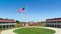
Baltimore - Fort McHenry Cam - Fort View
🇺🇸 Maryland · United States — Altitude 10 m
This live camera looks toward Fort McHenry, the star-shaped brick fort at the mouth of Baltimore's Patapsco River harbor. It is useful for checking the view and conditions on the water before you visit or simply to see the harbor at work. The live player, local time and weather are all shown on this page.
Fort McHenry sits on a low peninsula where the Patapsco River meets the Chesapeake Bay, a few kilometres south-east of downtown Baltimore. It is best known as the fort whose bombardment during the War of 1812 inspired Francis Scott Key to write the poem that became the lyrics of the United States national anthem. The surroundings are flat, open and shaped by water, with marshy shoreline and wide skies typical of the Chesapeake region.
The camera is pointed at the fort's view, so the most rewarding moments depend on the light and weather. Early mornings and late afternoons usually bring softer light on the brick walls and the water, while clear days show ships and boats moving through the harbor approach. Summer storms can bring dramatic clouds over the bay, and winter views are often sharper but colder. The exact scene you see depends on the view at any given moment.
Baltimore has a humid subtropical climate with hot, humid summers and mild winters, and spring and autumn are generally the most comfortable seasons. Fort McHenry is a short drive or water-taxi ride from the Inner Harbor. Other Baltimore cameras are listed nearby, including the Inner Harbor, Tropical Fish and Jellyfish cameras, all within a few kilometres of this view.
Source: earthcam.com
Maryland, United States — 3.4 km

Maryland, United States — 3.4 km
Maryland, United States — 3.5 km

Maryland, United States — 4 km
Maryland, United States — 14 km
Maryland, United States — 19 km
Maryland, United States — 24 km
Maryland, United States — 25 km
Maryland, United States — 38 km
Maryland, United States — 41 km
The current conditions and a 3-day forecast for Baltimore are shown in the weather block on this page. The values update as the page loads, so check there for the latest temperature and sky.
The local time in Baltimore, Maryland, is displayed on this page and follows Eastern Time. It is shown next to the live player so you can plan your viewing.
The camera is located at Fort McHenry in Baltimore, on the peninsula where the Patapsco River meets the Chesapeake Bay. The map on this page shows its exact position.
Early morning and late afternoon usually give the softest light on the fort and water, while clear days are best for seeing boats in the harbor. The view depends on weather and conditions at the time.
Partner links: we may earn a commission at no extra cost to you.