
Charlottesville - Boar’s Head Resort
Virginia, United States — 13 km
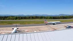
Charlottesville - Airport
🇺🇸 Virginia · United States — Altitude 188 m
This live camera looks out over Charlottesville Airport in central Virginia, a regional airfield serving the city and the surrounding Piedmont countryside. It suits anyone checking flight activity, sky conditions or simply the day's weather before heading out. The player is embedded from its source, with local time and forecast shown alongside.
Charlottesville sits in the rolling Piedmont of Virginia, at the foothills of the Blue Ridge Mountains, roughly 190 metres above sea level. It is best known as the home of the University of Virginia, whose Thomas Jefferson-designed grounds draw visitors year round, and as a gateway to the wineries and orchards of the surrounding countryside. The airport lies a short distance from the city and serves as a point of arrival for regional travellers.
The title names the airport, so the view is most likely centred on the airfield, runways and the apron rather than the town itself. Depending on the angle, you may see aircraft taking off, landing or taxiing, and the sky above the Virginia hills. Mornings and late afternoons often bring the clearest light, while summer thunderstorms can build quickly and change the scene within minutes.
Charlottesville has a humid subtropical climate with warm, humid summers and mild winters, and spring and autumn are generally the most pleasant seasons for a visit. Snow is possible in winter but seldom heavy. Nearby on VizCams you can also check the Boar's Head Resort camera about 13 km away, and the Massanutten resort cameras roughly 39 to 40 km distant in the Shenandoah area.
Source: earthcam.com
Virginia, United States — 13 km

Virginia, United States — 39 km

Virginia, United States — 39 km

Virginia, United States — 40 km

Virginia, United States — 46 km

Virginia, United States — 49 km

Virginia, United States — 50 km

Virginia, United States — 50 km

Virginia, United States — 50 km
Virginia, United States — 53 km
The current conditions and three-day forecast for Charlottesville are shown in the live weather block on this page, updated alongside the camera feed.
The local time for Charlottesville is displayed on this page and follows the Eastern time zone used across Virginia, including daylight saving changes.
The camera is located at Charlottesville Airport in Virginia, at about 188 metres altitude, and the map on this page marks its position for orientation.
Daytime hours generally offer the most activity and the clearest view. Weather changes can alter visibility, so check the live forecast before expecting a particular view.
Partner links: we may earn a commission at no extra cost to you.