
Vestmannaeyjar – Framhaldsskóli - Framhaldsskóli à Vestmannaeyjar
Southern Region, Iceland — 0.3 km
🇮🇸 Southern Region · Iceland — Altitude 5 m
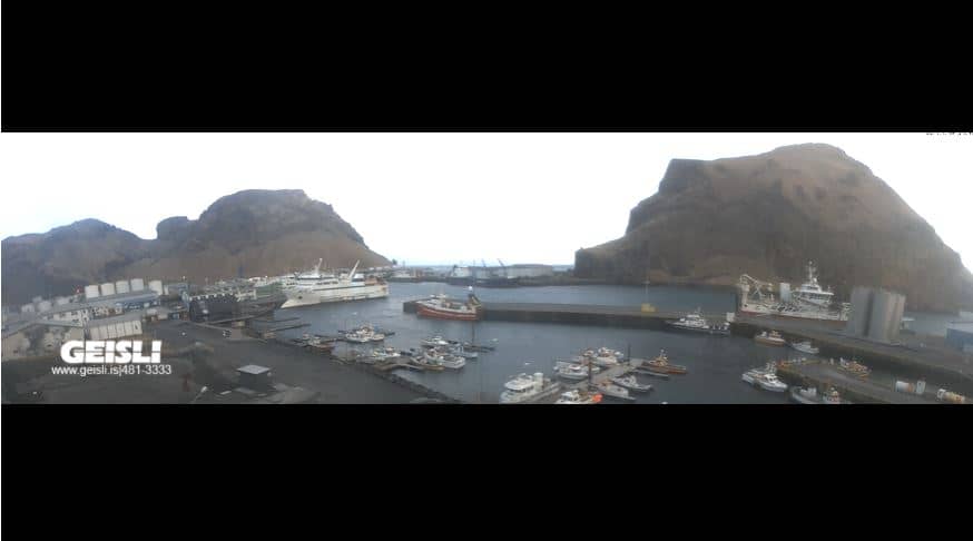
This live camera looks out over Vestmannaeyjar, the main town of the Westman Islands off Iceland's southern coast. It is a useful way to check how the harbour and island weather look right now before you plan a boat trip or a walk. The page also shows local time and the forecast for the next three days.
Vestmannaeyjar sits on Heimaey, the largest island of a small volcanic archipelago a few kilometres off the south coast of Iceland. The town was reshaped by the Eldfell eruption of 1973, when lava nearly closed the harbour and the island grew in size. Steep cliffs, grassy slopes and large seabird colonies define the landscape, and the sea is never far away. The air is mild for its latitude, and the light can change quickly as clouds roll in from the Atlantic.
The image is taken from the town area on Heimaey, so depending on the view you may see parts of the harbour, houses on the slopes and open water beyond. Because the camera is live, the best reason to watch is to see the current sky, sea state and visibility. Mornings and evenings often bring the clearest light for judging conditions, while stormy days show how the sea behaves around the islands. Puffins and other seabirds are common in the warmer months, though whether they appear in frame depends on the moment.
Vestmannaeyjar is reached by a short ferry crossing from the mainland, or by a small aircraft, and ferry times depend on weather and season. Summers are cool and windy, with temperatures usually in the low teens Celsius, while winters are mild but stormy. Late spring and summer are the easiest months for boat trips and birdwatching. The nearby cameras on the same site cover Gólfskálinn, the school area, Dalurinn and Ægisgata, so you can compare views across the town.
Source: Geisli
Southern Region, Iceland — 0.3 km

Southern Region, Iceland — 0.3 km

Southern Region, Iceland — 0.3 km

Southern Region, Iceland — 0.3 km

Southern Region, Iceland — 0.3 km

Southern Region, Iceland — 0.3 km
Southern Region, Iceland — 44 km

Southern Region, Iceland — 50 km
Southern Region, Iceland — 54 km

Southern Region, Iceland — 65 km
The current conditions and a three-day forecast are shown in the weather block on this page. They update with the page, so check them before any boat trip or walk along the coast.
The local time is displayed on this page and follows the Iceland clock, which is on UTC all year. The time block updates automatically while the page is open.
The camera is in the town of Vestmannaeyjar on Heimaey, the main island of the Westman Islands off Iceland's south coast. The map on the page shows its position.
Watching in the morning or evening usually gives the clearest light, and stormy days show the sea conditions most clearly. Summer brings the most birdlife, but the view depends on the weather at that moment.
Partner links: we may earn a commission at no extra cost to you.