
Lenzerheide - Heidsee - Bargias
Graubünden, Switzerland — 3.2 km

Lenzerheide - Piz Scalottas
🇨🇭 Graubünden · Switzerland — Altitude 2323 m
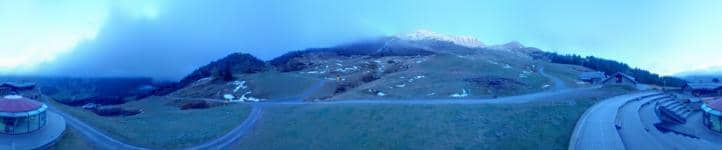
This camera looks out from the mountain range above Lenzerheide in the Swiss canton of Graubünden, at an altitude of about 2,300 metres. It is useful for checking how clear the peaks are and whether cloud is building before you plan a walk or ski day. The live player, local time and weather forecast are all shown on this page.
Lenzerheide is a resort village in the Albula Alps, a short drive from Chur and well connected by road and rail to the rest of the Grisons. The area is known for its open alpine meadows, larch forests and lakes, and it has long been a base for both summer hiking and winter sports. The Piz Scalottas ridge rises above the village and gives wide views over the surrounding peaks and valleys, which makes the location feel remote even though the resort is close by.
The camera follows the mountain landscape, so the most rewarding moments are usually early morning, when light falls across the ridges, and late afternoon, when the valleys begin to shade. Cloud movement and fresh snow on the summits are often easy to spot from here, which can tell you a lot about conditions higher up. Clear days give the sharpest view of the peaks, while low cloud can hide the ridge for hours at a time.
The region has a mountain climate, with cold, snowy winters and mild summers that bring hiking weather from June to September. Autumn is often calm and clear. Lenzerheide is reached by car from Chur, or by train and bus. Nearby cameras on this site cover the Heidsee lake, the Alp Stätz pasture and the Roland biathlon arena, which give you a fuller picture of the area in one visit.
Source: roundshot.com
Graubünden, Switzerland — 3.2 km

Graubünden, Switzerland — 4.1 km
Graubünden, Switzerland — 4.5 km

Graubünden, Switzerland — 4.7 km

Graubünden, Switzerland — 5.2 km

Graubünden, Switzerland — 5.7 km

Graubünden, Switzerland — 6.1 km

Graubünden, Switzerland — 7 km

Graubünden, Switzerland — 8.3 km

Graubünden, Switzerland — 10 km
The current conditions and a three-day forecast for this location are shown in the weather block on this page. Mountain weather can change quickly, so check it before setting out.
The local time for the camera is displayed on the page and updates automatically. Switzerland uses Central European Time, with summer time in the warmer months.
The camera is above Lenzerheide in the Grisons region of eastern Switzerland, at about 2,300 metres above sea level. The map on the page shows its exact position.
Early morning and late afternoon usually give the best light on the peaks. Clear days in winter and early autumn tend to offer the sharpest view of the surrounding mountains.
Partner links: we may earn a commission at no extra cost to you.