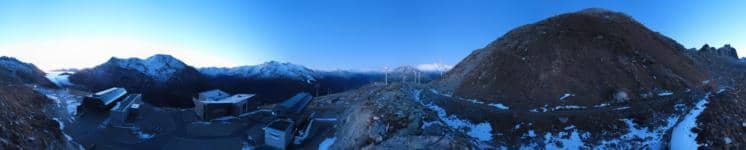
Andermatt - Gütsch
Uri, Switzerland — 3 km

Andermatt - Schneehüenerstock
🇨🇭 Uri · Switzerland — Altitude 2602 m
This camera looks out from the mountains above Andermatt, a village in the canton of Uri at about 2,600 metres. The live picture gives a sense of the high Alpine terrain and the changing conditions above the Urner Alps. Check it before you plan a day in the mountains or simply to see how the snow and cloud are moving.
Andermatt sits in the Urseren Valley, a wide high basin in the central Swiss Alps where the Gotthard, Furka and Oberalp routes meet. The village is known as a base for skiing, hiking and mountain biking, and its surroundings are marked by open alpine meadows, rocky ridges and peaks rising above the valley floor. The valley floor is high and open, so the air and light can change quickly.
The camera is titled after the Schneehüenerstock, a mountain peak above the village, so the view is likely to show high alpine ridges and slopes rather than the valley itself. Depending on the view, you may see snow cover, cloud moving over the ridges or the light shifting across the rock faces. Mornings often bring clear air and sharp shadows, while afternoons in the mountains can bring cloud build-up. Conditions depend on the season and weather.
Andermatt has a continental-leaning Alpine climate, with cold winters and cool summers, and snow usually lies on higher ground for much of the year. Summer is the usual time for hiking and walking, while winter brings skiing. Nearby cameras on the same site cover Gütsch, Baezberg, the golf course and Gemsstock, which can help you compare conditions across the area.
Above 2,000 metres conditions can change in minutes, so check the forecast on this page before heading out. Early and late in the day often give the steadiest view, and cloud can drop over ridges quickly. Use the live weather and local time shown below to judge when to go.
Source: roundshot.com
Uri, Switzerland — 3 km
Uri, Switzerland — 6.4 km
Uri, Switzerland — 7.3 km

Uri, Switzerland — 8.2 km

Graubünden, Switzerland — 11 km

Graubünden, Switzerland — 12 km

Graubünden, Switzerland — 13 km
Graubünden, Switzerland — 15 km

Graubünden, Switzerland — 15 km

Obwalden, Switzerland — 20 km
The current weather and a three-day forecast for this camera are shown in the live block on this page. Conditions at this altitude can differ from the valley below.
The local time for Andermatt is shown on this page and follows Swiss time. It updates with the live view.
The camera is in the Andermatt area of the canton of Uri, Switzerland, at roughly 2,600 metres altitude. A map on this page marks its position.
Clear mornings often show the sharpest detail and shadows, while afternoons can bring cloud. Winter gives snow-covered slopes and summer shows the open alpine landscape.
Partner links: we may earn a commission at no extra cost to you.